MaxiFleet

Leave nothing to chance

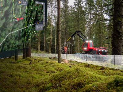
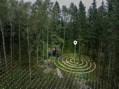
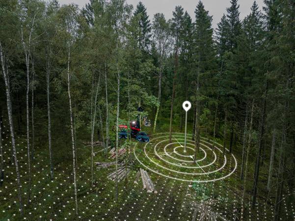
What would it mean to you to always know the smartest route to the timber with the least impact on the forest and well away from the waterlogged ground? To prepare tomorrow’s work from home so that the correct information is available at the start of the working day. Or to be able to allow a service technician to connect to your machine remotely to help you?


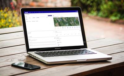
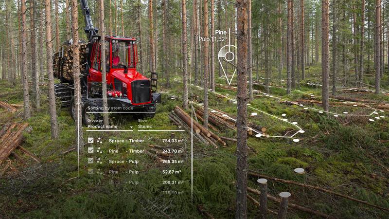
Our MaxiFleet digital service is a comprehensive tool that simplifies your working day - regardless of whether your fleet is comprised of one or one hundred forest machines. MaxiFleet helps you to keep track of your machines, collaborate with colleagues and make informed decisions based on facts. All of this is made possible by our MaxiXT control system, which processes vast amounts of data about your machine and its production. These data are then analysed in MaxiFleet, and the result is a number of help functions to simplify your working day and help you to make profitable and sustainable choices.

What can MaxiFleet do for you?

MaxiFleet Precision mindre

Precise positioning supports you in your work

Precision

Thanks to developments in the satellite positioning technology GNSS, MaxiFleet can now show the machine’s position to within just a few centimeters, providing the foundation for a new and exciting area, Precision.

There are several useful functions within Precision, like the ability to create exact, digital fences to mark the borders of a work area or around protected areas. It's also easier to classify stems based on environmental considerations with the stem code visualisation tool.

Read more about Precision here and more about stem code visualisation here. Hear the product manager for Connected products talk more about Precision in this video.
MaxiFleet work area management

Plan for better results

Work area management

MaxiFleet opens new doors for preparing and planning work tasks for harvesters and forwarders alike. As MaxiFleet is a cloud-based service, you can plan your work wherever you like and use any device with internet access. You can register identities, products, areas, maps, GIS data and other important information. This ensures that the operator has the correct information even before they start working and having the correct information also minimises the risk of unnecessary driving and mistakes.
MaxiFleet machine information

All machine information gathered in one place

Machine information

MaxiFleet gathers all machine information about your fleet and continually provides insights into each individual machine. You can see the utilisation, operating status, and exact geographic location of each machine. This entails no extra work for the operator as all data are logged and saved automatically.

It's easy to compare fuel consumption and production and the stored operation and production data are easy to tally, reducing your monthly accounts workload.
MaxiFleet interaction

Interaction, support and training

Interaction

MaxiFleet gives you remote access to many practical functions: check the battery status, monitor the temperature in the cab or start the diesel heater. Access to remote support where Komatsu Forest’s experts connect to your machine offers additional peace of mind. You can even allow a technician to remote control the machine, troubleshoot any problems and update the settings and software. This minimises downtime and saves both time and money - not least by avoiding costly service callout expenses. Technicians can provide remote training as well.
MaxiFleet worksite collaboration

Share information quickly and easily

Worksite collaboration

MaxiFleet and MaxiVision make it easy to share information with each other. The harvester operator plans suitable access roads, log roads and landings based on the worksite conditions. The forwarder operator can see the production in each working zone and optimise their forwarding to avoid unnecessary detours. Once the timber has been forwarded to the landing, the operator can mark the zone complete, simplifying follow-ups. Functions for marking particular areas and boundaries on the map and writing messages enable the team to help each other do a better job. You can also share information with other teams or companies. All information is updated in real-time.
MaxiFleet work site information

Efficient, low-impact work

Worksite information

MaxiFleet and MaxiVision helps you to work more efficiently and with less impact on the forest. You get area maps with up-to-date information You can plan the forwarding based on the harvester’s tracks, thereby saving time, diesel and the environment. You gain a good overview and reliable production data that make it easy to adjust your planning as needed. The map functions in MaxiFleet also make it easy to send an easily understood final report once an area has been completed.

Which level suits you?

MaxiFleet is built as a subscription with different service levels so you can find the one that suits you and your business.

Base
Basic level where you can access basic information from the machine overview. Our support staff can remotely connect to your machine, and you can remotely control the diesel heater and see the map in real time.
Advanced
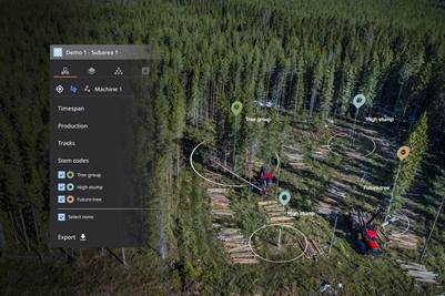
In addition to the content of the Base level, you can make comparisons, use data layers on maps, follow key performance indicators and view reports. You can also work with planning and follow-up of your felling object.
Advanced Plus
Here you have access to all the functionality in MaxiFleet. You also get the cloud-based map software MaxiVision, which gives you detailed information about the felling object and allows you to share information with other machines in the area. You can also remotely connect to your machines.